Sea Temperature
The surface temperature of the Patagonian Sea follows a seasonal cycle in response to variations in solar radiation, cloud cover, winds and marine currents.
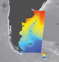
On the summer temperature map the effect of the entry of the cold sub-Antarctic waters of the Malvinas Current, which moves northwards, can be clearly identified. The effect of this current is present year round at the edge of the slope.
To the north are the warm waters of subtropical origin associated with the Brazil Current that move southwards and other local coastal maxima like the Río de la Plata and El Rincón.